Geolocate

Wauchula topographic map

Click on the map to display elevation.

About this map

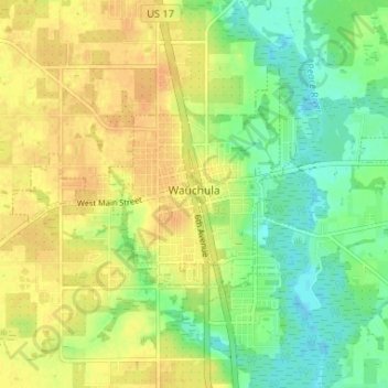
Name: Wauchula topographic map, elevation, terrain.

Location: Wauchula, Hardee County, Florida, 33873, United States (27.52743 -81.84205 27.56586 -81.77675)

Average elevation: 30 m

Minimum elevation: 13 m

Maximum elevation: 43 m

Gear up for your next adventure:

🧰Multitool Knife - Compact and versatile tool for outdoor use
🥾Hiking Shorts - Breathable shorts suitable for summer hikes
🐕Hiking Dog Pack - Let your canine companion carry their own water and food
🛶Kayak Dry Bag - Waterproof storage for kayaking adventures
🧥Thermal Fleece Jacket - Versatile insulation for changing mountain temperatures

As an Amazon Associate, this site earns from qualifying purchases at no extra cost to you.