Geolocate

El Salto topographic map

Click on the map to display elevation.

About this map

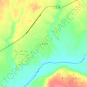
Name: El Salto topographic map, elevation, terrain.

Location: El Salto, Tambo Grande, Province of Piura, Piura, Peru (-4.94187 -80.52640 -4.90187 -80.48640)

Average elevation: 73 m

Minimum elevation: 42 m

Maximum elevation: 114 m

Gear up for your next adventure:

🧤Insulated Winter Gloves - Heavy-duty protection for sub-zero Canadian adventures
🐕Hiking Dog Pack - Let your canine companion carry their own water and food
🥾Approach Boots - Comfortable boots for hiking and climbing approaches
🔦UV Flashlight - Detect minerals or specific insects in the dark
🧭GPS Tracker - Track your location in remote areas safely

As an Amazon Associate, this site earns from qualifying purchases at no extra cost to you.