Geolocate

Annonay topographic map

Click on the map to display elevation.

About this map
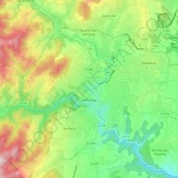
Name: Annonay topographic map, elevation, terrain.

Location: Annonay, Tournon-sur-Rhône, Ardèche, Auvergne-Rhône-Alpes, Metropolitan France, 07100, France (45.22062 4.58475 45.26916 4.69905)

Average elevation: 453 m

Minimum elevation: 221 m

Maximum elevation: 825 m

Other topographic maps

Click on a map to view its topography, its elevation and its terrain.

Tabias

France > Auvergne-Rhône-Alpes > Ardèche > Lagorce

Average elevation: 168 m

Beguet

France > Auvergne-Rhône-Alpes > Ardèche > Boffres

Average elevation: 626 m

Valens

France > Auvergne-Rhône-Alpes > Ardèche > Rompon

Average elevation: 236 m

Auriolles

France > Auvergne-Rhône-Alpes > Ardèche

Average elevation: 136 m

Desroches

France > Auvergne-Rhône-Alpes > Ardèche > Lemps

Average elevation: 379 m

Chazotte

France > Auvergne-Rhône-Alpes > Ardèche > Balazuc

Average elevation: 193 m

Cluac

France > Auvergne-Rhône-Alpes > Ardèche > Saint-Basile

Average elevation: 747 m

Benevis

France > Auvergne-Rhône-Alpes > Ardèche > Félines

Average elevation: 322 m

Le Bescut

France > Auvergne-Rhône-Alpes > Ardèche > Veyras

Average elevation: 411 m

Les Matrons

France > Auvergne-Rhône-Alpes > Ardèche > Ardoix

Average elevation: 336 m

Valens

France > Auvergne-Rhône-Alpes > Ardèche > Rompon

Average elevation: 236 m

La Gare

France > Auvergne-Rhône-Alpes > Ardèche > Grospierres

Average elevation: 171 m

Chalos

France > Auvergne-Rhône-Alpes > Ardèche > Rompon

Average elevation: 307 m

Gear up for your next adventure:

💡Compact LED Flashlight - Powerful and portable flashlight for outdoor use
🥾Hiking Shorts - Breathable shorts suitable for summer hikes
🛏️Sleeping Bag - Warm and compact sleeping bags for outdoor camping
🧴First Aid Kit - Essential first aid supplies for outdoor emergencies
🥾Waterproof Hiking Shoes - Durable shoes for wet and rugged trails

As an Amazon Associate, this site earns from qualifying purchases at no extra cost to you.