Geolocate

Cherokee topographic map

Click on the map to display elevation.

About this map

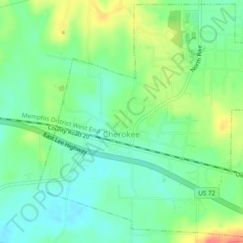
Name: Cherokee topographic map, elevation, terrain.

Location: Cherokee, Colbert County, Alabama, 35662, United States (34.74540 -87.98420 34.77147 -87.95333)

Average elevation: 165 m

Minimum elevation: 144 m

Maximum elevation: 201 m

Other topographic maps

Click on a map to view its topography, its elevation and its terrain.

Barton

United States > Alabama > Colbert County

Average elevation: 160 m

Ford City

United States > Alabama > Colbert County

Average elevation: 176 m

Leighton

United States > Alabama > Colbert County

Average elevation: 176 m

Gear up for your next adventure:

🥾Trail Running Shoes - Lightweight and durable shoes for trail running
🧥Softshell Jacket - Windproof and breathable jacket for hiking
🥾Approach Boots - Comfortable boots for hiking and climbing approaches
🥾Durable Hiking Shoes - Long-lasting shoes for frequent hiking
🥾Trekking Poles - Adjustable trekking poles to reduce knee stress and improve stability

As an Amazon Associate, this site earns from qualifying purchases at no extra cost to you.