Geolocate

McCorkle topographic map

Click on the map to display elevation.

About this map

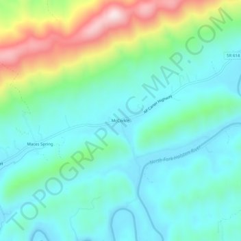
Name: McCorkle topographic map, elevation, terrain.

Location: McCorkle, Scott County, Virginia, United States (36.65621 -82.40598 36.69621 -82.36598)

Average elevation: 518 m

Minimum elevation: 393 m

Maximum elevation: 890 m

Other topographic maps

Click on a map to view its topography, its elevation and its terrain.

Duffield

United States > Virginia > Scott County

Average elevation: 453 m

Weber City

United States > Virginia > Scott County

Average elevation: 440 m

Clinchport

United States > Virginia > Scott County

Average elevation: 457 m

Gate City

United States > Virginia > Scott County

Average elevation: 488 m

Gear up for your next adventure:

🔦UV Flashlight - Detect minerals or specific insects in the dark
🧥Softshell Jacket - Windproof and breathable jacket for hiking
🔥Emergency Fire Starter - Reliable ignition source for all weather conditions
🥾Approach Boots - Comfortable boots for hiking and climbing approaches
👟Leg Gaiters - Keep debris, mud, and snow out of your boots

As an Amazon Associate, this site earns from qualifying purchases at no extra cost to you.