Geolocate

Gate City topographic map

Click on the map to display elevation.

About this map

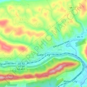
Name: Gate City topographic map, elevation, terrain.

Location: Gate City, Scott County, Virginia, 24251, United States (36.62482 -82.61395 36.66345 -82.55293)

Average elevation: 488 m

Minimum elevation: 380 m

Maximum elevation: 673 m

Other topographic maps

Click on a map to view its topography, its elevation and its terrain.

Craft Mill

United States > Virginia > Scott County

Average elevation: 490 m

Hiltons

United States > Virginia > Scott County

Average elevation: 513 m

McCorkle

United States > Virginia > Scott County

Average elevation: 518 m

Purchase Knob

United States > Virginia > Scott County

Average elevation: 507 m

Gear up for your next adventure:

🥾Durable Hiking Shoes - Long-lasting shoes for frequent hiking
🥾Hiking Boots - Sturdy boots providing ankle support and traction on rugged trails
🏃Hydration Running Vest - Carry water and maps close to your body for speed
💧Reusable Water Bottle - Durable water bottles for hydration on trails
🧰Emergency Multi-Tool - Compact multi-tool for outdoor survival

As an Amazon Associate, this site earns from qualifying purchases at no extra cost to you.