
Make a donation
Gear up for your next adventure:
As an Amazon Associate, this site earns from qualifying purchases at no extra cost to you.
Weslemkoon Lake topographic map
Click on the map to display elevation.
Make a donation
Gear up for your next adventure:
As an Amazon Associate, this site earns from qualifying purchases at no extra cost to you.
About this map
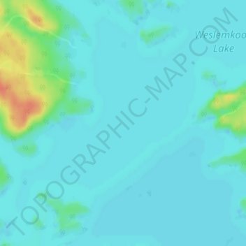
Name: Weslemkoon Lake topographic map, elevation, terrain.
Average elevation: 324 m
Minimum elevation: 316 m
Maximum elevation: 361 m
Lennox and Addington County trails, hiking, mountain biking, running and outdoor activities
Make a donation
Gear up for your next adventure:
As an Amazon Associate, this site earns from qualifying purchases at no extra cost to you.
Other topographic maps
Click on a map to view its topography, its elevation and its terrain.
Joeperry Lake
Canada > Ontario > Lennox and Addington County > Addington Highlands
Joeperry Lake is the source of the Skootamatta River. It is about 2.2 kilometres (1.4 mi) long and 2.2 kilometres (1.4 mi) wide, and lies at an elevation of 315 metres (1,033 ft). There is one inflow, an unnamed creek at the west of the lake. The primary outflow is the Skootamatta River, on the south side of…
Average elevation: 328 m
Bon Echo Provincial Park
Canada > Ontario > Lennox and Addington County > Addington Highlands
Average elevation: 321 m
Bon Echo Lake
Canada > Ontario > Lennox and Addington County > Addington Highlands
Average elevation: 313 m
Upper Mazinaw Lake
Canada > Ontario > Lennox and Addington County > Addington Highlands
Average elevation: 296 m
Make a donation
Gear up for your next adventure:
As an Amazon Associate, this site earns from qualifying purchases at no extra cost to you.
Denbigh Lake
Canada > Ontario > Lennox and Addington County > Addington Highlands > Denbigh
Average elevation: 372 m
Grimsthorpe Lake
Canada > Ontario > Lennox and Addington County > Addington Highlands
Average elevation: 336 m
Skootamatta Lake
Canada > Ontario > Lennox and Addington County > Addington Highlands
Average elevation: 301 m
Weslemkoon Lake
Canada > Ontario > Lennox and Addington County > Addington Highlands
Average elevation: 349 m
Make a donation
Gear up for your next adventure:
As an Amazon Associate, this site earns from qualifying purchases at no extra cost to you.
Bon Echo Provincial Park
Canada > Ontario > Lennox and Addington County > Addington Highlands
Average elevation: 321 m