
Make a donation
Gear up for your next adventure:
As an Amazon Associate, this site earns from qualifying purchases at no extra cost to you.
Upper Mazinaw Lake topographic map
Click on the map to display elevation.
Make a donation
Gear up for your next adventure:
As an Amazon Associate, this site earns from qualifying purchases at no extra cost to you.
About this map
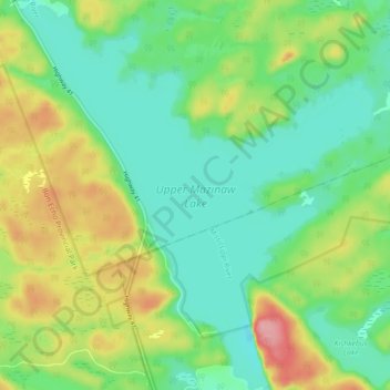
Name: Upper Mazinaw Lake topographic map, elevation, terrain.
Average elevation: 296 m
Minimum elevation: 254 m
Maximum elevation: 378 m
Lennox and Addington County trails, hiking, mountain biking, running and outdoor activities
Make a donation
Gear up for your next adventure:
As an Amazon Associate, this site earns from qualifying purchases at no extra cost to you.
Other topographic maps
Click on a map to view its topography, its elevation and its terrain.
Weslemkoon Lake
Canada > Ontario > Lennox and Addington County > Addington Highlands
Average elevation: 324 m
Bon Echo Lake
Canada > Ontario > Lennox and Addington County > Addington Highlands
Average elevation: 313 m
Northbrook
Canada > Ontario > Lennox and Addington County > Addington Highlands
Average elevation: 260 m
Make a donation
Gear up for your next adventure:
As an Amazon Associate, this site earns from qualifying purchases at no extra cost to you.