
Make a donation
Gear up for your next adventure:
As an Amazon Associate, this site earns from qualifying purchases at no extra cost to you.
Ulverley Green topographic map
Click on the map to display elevation.
Make a donation
Gear up for your next adventure:
As an Amazon Associate, this site earns from qualifying purchases at no extra cost to you.
About this map
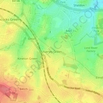
Name: Ulverley Green topographic map, elevation, terrain.
Average elevation: 123 m
Minimum elevation: 92 m
Maximum elevation: 157 m
Make a donation
Gear up for your next adventure:
As an Amazon Associate, this site earns from qualifying purchases at no extra cost to you.
Other topographic maps
Click on a map to view its topography, its elevation and its terrain.
Hockley Heath
United Kingdom > England > Metropolitan Borough of Solihull
By the 18th century the manor had passed to the Archers of Umberslade Hall and the hamlet was briefly reoriented around its Umberslade area. The Umberslade estate sits on the border of Nuthurst and Tanworth in Arden and had been built for the Archer family in 1680. Lord Archer raised a 70 feet (21 m) limestone…
Average elevation: 134 m
Little Clowes Wood
United Kingdom > England > Metropolitan Borough of Solihull > Tidbury Green
Average elevation: 150 m
Make a donation
Gear up for your next adventure:
As an Amazon Associate, this site earns from qualifying purchases at no extra cost to you.
Kingshurst
United Kingdom > England > Metropolitan Borough of Solihull > Kingshurst
Average elevation: 91 m
Make a donation
Gear up for your next adventure:
As an Amazon Associate, this site earns from qualifying purchases at no extra cost to you.