Geolocate

Bentley topographic map

Click on the map to display elevation.

About this map

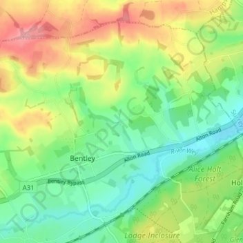
Name: Bentley topographic map, elevation, terrain.

Location: Bentley, East Hampshire, Hampshire, England, United Kingdom (51.17997 -0.90153 51.21274 -0.83805)

Average elevation: 113 m

Minimum elevation: 70 m

Maximum elevation: 179 m

Gear up for your next adventure:

🥾Hiking Gaiters - Protect legs and shoes from mud, snow, and debris
🪑Insulated Seat Pad - Protect your seat from cold rocks and wet logs
🥾Waterproof Trail Shoes - Shoes designed to handle wet terrain
💧Hydration Pack - Hands-free hydration system for long hikes
🥾Trail Hiking Shoes - Durable shoes designed for rugged trails

As an Amazon Associate, this site earns from qualifying purchases at no extra cost to you.