
Make a donation
Gear up for your next adventure:
As an Amazon Associate, this site earns from qualifying purchases at no extra cost to you.
Parque Los Caobos topographic map
Click on the map to display elevation.
Make a donation
Gear up for your next adventure:
As an Amazon Associate, this site earns from qualifying purchases at no extra cost to you.
About this map
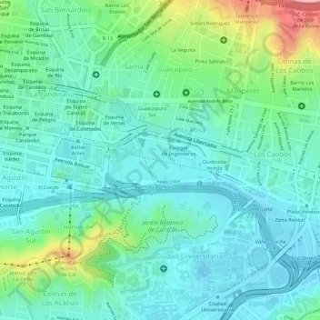
Name: Parque Los Caobos topographic map, elevation, terrain.
Average elevation: 903 m
Minimum elevation: 859 m
Maximum elevation: 1,025 m
Make a donation
Gear up for your next adventure:
As an Amazon Associate, this site earns from qualifying purchases at no extra cost to you.
Other topographic maps
Click on a map to view its topography, its elevation and its terrain.
Caracas
Venezuela > Distrito Capital > Caracas
El valle es relativamente pequeño y bastante irregular. La ciudad cuenta con una superficie de 845 km². La altitud respecto al nivel del mar varía de un punto a otro de la ciudad, entre los 870 y los 1443 m s. n. m. en el área urbana, con 900 m en su centro histórico. El punto más elevado es el Pico…
Average elevation: 858 m