
Make a donation
Gear up for your next adventure:
As an Amazon Associate, this site earns from qualifying purchases at no extra cost to you.
Caracas topographic map
Click on the map to display elevation.
Make a donation
Gear up for your next adventure:
As an Amazon Associate, this site earns from qualifying purchases at no extra cost to you.
Caracas
Cerro El Ávila (Mountain El Ávila) (Indigenous name: Waraira Repano), is a mountain in the mid-North of Venezuela. It rises next to Caracas and separates the city from the Caribbean Sea; The area's highest elevation is Pico Naiguatá, at 2,765 metres (9,072 ft) above sea level. It is considered the lungs of Caracas due to the amount of vegetation on the mountain.
Make a donation
Gear up for your next adventure:
As an Amazon Associate, this site earns from qualifying purchases at no extra cost to you.
About this map
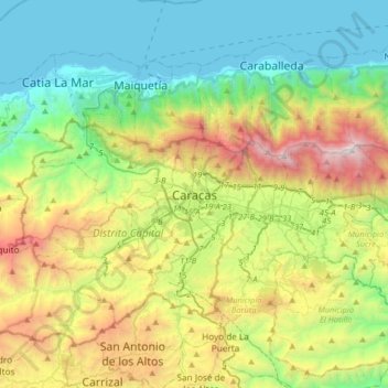
Name: Caracas topographic map, elevation, terrain.
Average elevation: 858 m
Minimum elevation: -1 m
Maximum elevation: 2,731 m
Make a donation
Gear up for your next adventure:
As an Amazon Associate, this site earns from qualifying purchases at no extra cost to you.