Geolocate

Klang topographic map

Click on the map to display elevation.

About this map

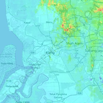
Name: Klang topographic map, elevation, terrain.

Location: Klang, Selangor, 41400, Malaysia (2.88715 101.28921 3.20715 101.60921)

Average elevation: 13 m

Minimum elevation: -28 m

Maximum elevation: 252 m

Other topographic maps

Click on a map to view its topography, its elevation and its terrain.

Pulau Indah

Malaysia > Selangor > Klang

Average elevation: 3 m

Langat River

Malaysia > Selangor > Klang > Jenjarom

Average elevation: 4 m

Gear up for your next adventure:

💡Portable Camping Lamp - Rechargeable lamp for campsite lighting
🥾Trekking Boots - Durable boots for long-distance trekking
🥾Light Trekking Boots - Supportive boots for multi-day treks
🛏️Camping Sleeping Mat - Comfortable mats for sleeping outdoors
🧢Hiking Hat - Sun-protective and breathable hats for long treks

As an Amazon Associate, this site earns from qualifying purchases at no extra cost to you.