
Make a donation
Gear up for your next adventure:
As an Amazon Associate, this site earns from qualifying purchases at no extra cost to you.
Garrotxa topographic map
Click on the map to display elevation.
Make a donation
Gear up for your next adventure:
As an Amazon Associate, this site earns from qualifying purchases at no extra cost to you.
About this map
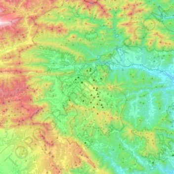
Name: Garrotxa topographic map, elevation, terrain.
Location: Garrotxa, Gerunda, Catalunha, Espanha (42.01213 2.33219 42.33407 2.77918)
Average elevation: 659 m
Minimum elevation: 120 m
Maximum elevation: 1,854 m
Make a donation
Gear up for your next adventure:
As an Amazon Associate, this site earns from qualifying purchases at no extra cost to you.
Other topographic maps
Click on a map to view its topography, its elevation and its terrain.
Make a donation
Gear up for your next adventure:
As an Amazon Associate, this site earns from qualifying purchases at no extra cost to you.
Make a donation
Gear up for your next adventure:
As an Amazon Associate, this site earns from qualifying purchases at no extra cost to you.
Serra de la Coma
Espanha > Catalunha > Alt Urgell > Ribera d'Urgellet > La Freita
Average elevation: 1,011 m