Geolocate

Beaverlodge topographic map

Click on the map to display elevation.

About this map

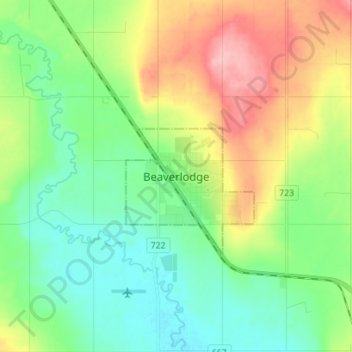
Name: Beaverlodge topographic map, elevation, terrain.

Location: Beaverlodge, Town of Beaverlodge, Alberta, T0H 0C0, Canada (55.17062 -119.46867 55.25062 -119.38867)

Average elevation: 735 m

Minimum elevation: 692 m

Maximum elevation: 818 m

Town of Beaverlodge trails, hiking, mountain biking, running and outdoor activities

Gear up for your next adventure:

🥫Freeze-Dried Meals - Lightweight, high-calorie nutrition for multi-day treks
🧴Waterproofing Spray - Restore the DWR coating on jackets and tents
👟Sport Hiking Sandals - Breathable footwear for water crossings and camp rest
💧Reusable Water Bottle - Durable water bottles for hydration on trails
🥾All-Terrain Hiking Boots - Versatile boots for varied hiking conditions

As an Amazon Associate, this site earns from qualifying purchases at no extra cost to you.