
Make a donation
Gear up for your next adventure:
As an Amazon Associate, this site earns from qualifying purchases at no extra cost to you.
Bern topographic map
Click on the map to display elevation.
Make a donation
Gear up for your next adventure:
As an Amazon Associate, this site earns from qualifying purchases at no extra cost to you.
About this map
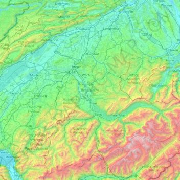
Name: Bern topographic map, elevation, terrain.
Location: Bern, Switzerland (46.32652 6.86148 47.34531 8.45516)
Average elevation: 1,131 m
Minimum elevation: 360 m
Maximum elevation: 4,158 m
Make a donation
Gear up for your next adventure:
As an Amazon Associate, this site earns from qualifying purchases at no extra cost to you.
Other topographic maps
Click on a map to view its topography, its elevation and its terrain.
Lausanne
Switzerland > Vaud > District de Lausanne > Lausanne
The most important geographical feature of the area surrounding Lausanne is Lake Geneva (Lac Léman in French). Lausanne is built on the southern slope of the Swiss plateau, with a difference in elevation of about 500 metres (1,640 ft) between the lakeshore at Ouchy and its northern edge bordering Le…
Average elevation: 577 m
Make a donation
Gear up for your next adventure:
As an Amazon Associate, this site earns from qualifying purchases at no extra cost to you.
Monte Rosa
Switzerland > Wallis > Visp > Zermatt
The peak is distinguished by the name Dufourspitze (in German, lit. Dufour Peak; French: Pointe Dufour, Italian: Punta Dufour). This replaced the former name Höchste Spitze (English: Highest Peak) that was indicated on the Swiss maps before the Federal Council, on January 28, 1863, decided to rename the…
Average elevation: 4,033 m
Filisur
Switzerland > Grisons > Albula > Bergün Filisur
Before 2017, the municipality was located in the Bergün subdistrict of the Albula district, since 2017 it is part of the Albula Region. It consists of the village of Filisur and the hamlet of Jenisberg at an elevation of 1,504 m (4,934 ft).
Average elevation: 1,319 m
Ramosch
Switzerland > Grisons > Region Engiadina Bassa/Val Müstair > Valsot
Average elevation: 1,501 m
Make a donation
Gear up for your next adventure:
As an Amazon Associate, this site earns from qualifying purchases at no extra cost to you.
Mathon
Switzerland > Grisons > Viamala > Muntogna da Schons > Donat
Before 2017, the former municipality was located in the Schams sub-district, of the Hinterrhein district, after 2017 it was part of the Viamala Region. The village is a haufendorf (an irregular, unplanned and quite closely packed village, built around a central square) at an elevation of 1,521 m (4,990 ft) in…
Average elevation: 1,520 m
Make a donation
Gear up for your next adventure:
As an Amazon Associate, this site earns from qualifying purchases at no extra cost to you.
Remis
Switzerland > St. Gallen > Wahlkreis Toggenburg > Kirchberg (SG) > Kirchberg SG
Average elevation: 717 m
Make a donation
Gear up for your next adventure:
As an Amazon Associate, this site earns from qualifying purchases at no extra cost to you.
Gmünde
Switzerland > Bern > Emmental administrative district > Langnau im Emmental
Average elevation: 1,013 m
Make a donation
Gear up for your next adventure:
As an Amazon Associate, this site earns from qualifying purchases at no extra cost to you.
Make a donation
Gear up for your next adventure:
As an Amazon Associate, this site earns from qualifying purchases at no extra cost to you.
Mattenbachfälle
Switzerland > Bern > Interlaken-Oberhasli administrative district > Stechelberg
Average elevation: 1,689 m
Port
Switzerland > Bern > Frutigen-Niedersimmental administrative district > Adelboden > Schönbühl
Average elevation: 1,415 m
Make a donation
Gear up for your next adventure:
As an Amazon Associate, this site earns from qualifying purchases at no extra cost to you.