Geolocate

Jordan topographic map

Click on the map to display elevation.

About this map

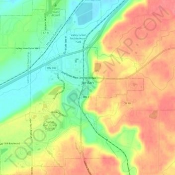
Name: Jordan topographic map, elevation, terrain.

Location: Jordan, Scott County, Minnesota, United States (44.64499 -93.65465 44.68516 -93.60808)

Average elevation: 260 m

Minimum elevation: 221 m

Maximum elevation: 295 m

Other topographic maps

Click on a map to view its topography, its elevation and its terrain.

Savage

United States > Minnesota > Scott County > Savage > Savage

Average elevation: 251 m

Shakopee

United States > Minnesota > Scott County > Shakopee > Shakopee

Average elevation: 248 m

Gear up for your next adventure:

🥾All-Terrain Hiking Boots - Versatile boots for varied hiking conditions
🛁Quick-Dry Microfiber Towel - Space-saving towel that dries rapidly on the move
🧴Outdoor Sunscreen - High SPF protection for high-altitude UV exposure
🧥Ultralight Puffy Jacket - Maximum warmth that packs down to the size of an orange
🥾Mountain Trail Shoes - High-traction shoes for mountain trails

As an Amazon Associate, this site earns from qualifying purchases at no extra cost to you.