Geolocate

Chiniak topographic map

Click on the map to display elevation.

About this map

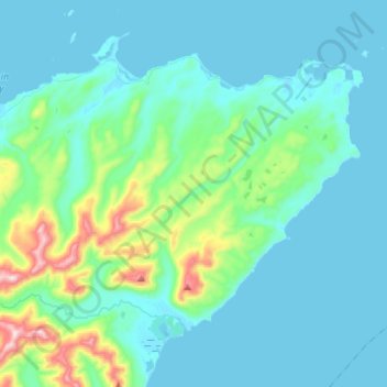
Name: Chiniak topographic map, elevation, terrain.

Location: Chiniak, Kodiak Island, Alaska, United States (57.52369 -152.42447 57.62585 -152.15533)

Average elevation: 86 m

Minimum elevation: -3 m

Maximum elevation: 614 m

Other topographic maps

Click on a map to view its topography, its elevation and its terrain.

Kodiak

United States > Alaska > Kodiak Island

Average elevation: 62 m

Kodiak

United States > Alaska > Kodiak Island

Average elevation: 87 m

Gear up for your next adventure:

❄️Traction Ice Cleats - Slip-on spikes for icy trails and winter hiking
🥾Trail Hiking Boots - Supportive boots for rough trails
🥾Hiking Shorts - Breathable shorts suitable for summer hikes
🥾Light Trekking Boots - Supportive boots for multi-day treks
🦌Outdoor Trail Camera - Monitor wildlife activity near your favorite spots

As an Amazon Associate, this site earns from qualifying purchases at no extra cost to you.