Geolocate

Kodiak topographic map

Click on the map to display elevation.

About this map

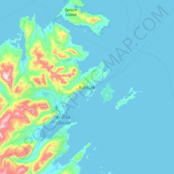
Name: Kodiak topographic map, elevation, terrain.

Location: Kodiak, Kodiak Island, Alaska, United States (57.63000 -152.56722 57.95000 -152.24722)

Average elevation: 87 m

Minimum elevation: -3 m

Maximum elevation: 864 m

Gear up for your next adventure:

🚲MTB Frame Bag - Carry tools and maps directly on your bicycle frame
🔪Outdoor Multitool - Versatile tool for repairs and food prep in the wild
🦶Anti-Blister Balm - Prevents friction and hotspots during long ascents
🔦LED Headtorch - Bright and durable light for night activities
🥾Hiking Shoes - Durable and comfortable shoes for trail hiking

As an Amazon Associate, this site earns from qualifying purchases at no extra cost to you.