Geolocate

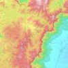
Thekkady topographic map

Click on the map to display elevation.

About this map

Name: Thekkady topographic map, elevation, terrain.

Location: Thekkady, Peerumade, Idukki, Kerala, 685536, India (9.56050 77.16114 9.60050 77.20114)

Average elevation: 932 m

Minimum elevation: 854 m

Maximum elevation: 1,187 m

Other topographic maps

Click on a map to view its topography, its elevation and its terrain.
Thengakal

India > Kerala > Peerumade > Keerikkara

Average elevation: 859 m

Periyar National Park Tiger Reserve

India > Kerala > Peerumade

Periyar National Park lies in the middle of a mountainous area of the Cardamom Hills. In the north : The boundary commences from the point nearest to the Medaganam in the interstate boundary up to Vellimalai. and the east Thence the boundary follows the inter-state boundary from Vellimalai to Kallimalai Peak…

Average elevation: 929 m

Periyar Lake

India > Kerala > Peerumade > Thekkady

Average elevation: 961 m

Mullaperiyar Dam

India > Kerala > Peerumade

Average elevation: 922 m

Azhutha

India > Kerala > Peerumade > Peermade

Average elevation: 838 m

Gear up for your next adventure:

📷Outdoor Action Camera - Capture high-elevation views and rugged adventures
🥾Trail Running Shoes - Lightweight and durable shoes for trail running
🥾Trekking Boots - Durable boots for long-distance trekking
🧢Sun Hat - Wide-brim hat for sun protection
🧼Biodegradable Camp Soap - Environmentally friendly cleaning for gear and body

As an Amazon Associate, this site earns from qualifying purchases at no extra cost to you.