Geolocate

Coniston topographic map

Click on the map to display elevation.

About this map

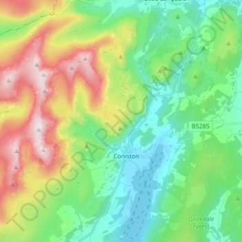
Name: Coniston topographic map, elevation, terrain.

Location: Coniston, Westmorland and Furness, England, United Kingdom (54.34057 -3.13139 54.41945 -3.02986)

Average elevation: 283 m

Minimum elevation: 45 m

Maximum elevation: 796 m

Other topographic maps

Click on a map to view its topography, its elevation and its terrain.

Gear up for your next adventure:

🧴Waterproofing Spray - Restore the DWR coating on jackets and tents
🧊Insulated Water Bottle - Keeps drinks cold in summer and prevents freezing in winter
🧰Survival Kit - Essential gear for emergencies in the wilderness
🥾Durable Hiking Shoes - Long-lasting shoes for frequent hiking
Lightweight Backpacking Tent - Compact tent for efficient hiking trips

As an Amazon Associate, this site earns from qualifying purchases at no extra cost to you.