
Make a donation
Gear up for your next adventure:
As an Amazon Associate, this site earns from qualifying purchases at no extra cost to you.
Lake Albert topographic map
Click on the map to display elevation.
Make a donation
Gear up for your next adventure:
As an Amazon Associate, this site earns from qualifying purchases at no extra cost to you.
Lake Albert
It is about 160 kilometres (99 mi) long and 30 kilometres (19 mi) across at its widest, with a maximum depth of 51 metres (167 ft), and a surface elevation of 619 metres (2,031 ft) above sea level.
Make a donation
Gear up for your next adventure:
As an Amazon Associate, this site earns from qualifying purchases at no extra cost to you.
About this map
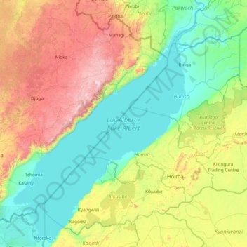
Name: Lake Albert topographic map, elevation, terrain.
Location: Lake Albert, Hoima, Western Region, Uganda (0.99817 30.35050 2.51412 31.53419)
Average elevation: 1,076 m
Minimum elevation: 607 m
Maximum elevation: 2,389 m
Make a donation
Gear up for your next adventure:
As an Amazon Associate, this site earns from qualifying purchases at no extra cost to you.
Other topographic maps
Click on a map to view its topography, its elevation and its terrain.
Make a donation
Gear up for your next adventure:
As an Amazon Associate, this site earns from qualifying purchases at no extra cost to you.