
Make a donation
Gear up for your next adventure:
As an Amazon Associate, this site earns from qualifying purchases at no extra cost to you.
Karongo topographic map
Click on the map to display elevation.
Make a donation
Gear up for your next adventure:
As an Amazon Associate, this site earns from qualifying purchases at no extra cost to you.
About this map
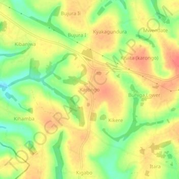
Name: Karongo topographic map, elevation, terrain.
Location: Karongo, Hoima, Western Region, Uganda (1.45746 31.28241 1.49746 31.32241)
Average elevation: 1,100 m
Minimum elevation: 1,070 m
Maximum elevation: 1,121 m
Make a donation
Gear up for your next adventure:
As an Amazon Associate, this site earns from qualifying purchases at no extra cost to you.
Other topographic maps
Click on a map to view its topography, its elevation and its terrain.
Lake Albert
It is about 160 kilometres (99 mi) long and 30 kilometres (19 mi) across at its widest, with a maximum depth of 51 metres (167 ft), and a surface elevation of 619 metres (2,031 ft) above sea level.
Average elevation: 1,076 m