Geolocate

Frias topographic map

Click on the map to display elevation.

About this map

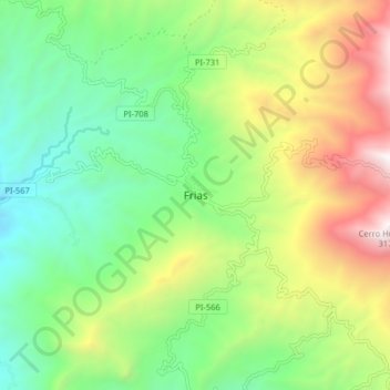
Name: Frias topographic map, elevation, terrain.

Location: Frias, Frías, Province of Ayabaca, Piura, Peru (-4.97163 -79.98737 -4.89163 -79.90737)

Average elevation: 1,846 m

Minimum elevation: 1,115 m

Maximum elevation: 3,134 m

Gear up for your next adventure:

🥾Hiking Shoes - Durable and comfortable shoes for trail hiking
🧥Waterproof Jacket - Lightweight rain jackets for hiking and outdoor activities
🔦LED Headlamp - Hands-free lighting for early morning starts or late finishes
🪜Heavy Duty Carabiners - Multi-use clips for securing gear to your backpack
❄️Traction Ice Cleats - Slip-on spikes for icy trails and winter hiking

As an Amazon Associate, this site earns from qualifying purchases at no extra cost to you.