Geolocate

Bergen topographic map

Click on the map to display elevation.

About this map

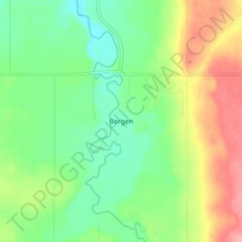
Name: Bergen topographic map, elevation, terrain.

Location: Bergen, Mountain View County, Alberta, Canada (51.68666 -114.65724 51.72666 -114.61724)

Average elevation: 1,159 m

Minimum elevation: 1,122 m

Maximum elevation: 1,214 m

Mountain View County trails, hiking, mountain biking, running and outdoor activities

Other topographic maps

Click on a map to view its topography, its elevation and its terrain.

Crown Land

Canada > Alberta > Mountain View County

Average elevation: 1,035 m

Gear up for your next adventure:

🧊Portable Cooler - Keep food and drinks cold during outdoor adventures
🦶Anti-Blister Balm - Prevents friction and hotspots during long ascents
🪑Ultralight Camping Stool - Compact seating for rest stops during long hikes
🧦Hiking Liner Socks - Thin base layer to prevent friction and blisters
🦶Hiking Shoe Insoles - Added support for high arches and long days on feet

As an Amazon Associate, this site earns from qualifying purchases at no extra cost to you.