Geolocate

Hook End topographic map

Click on the map to display elevation.

About this map

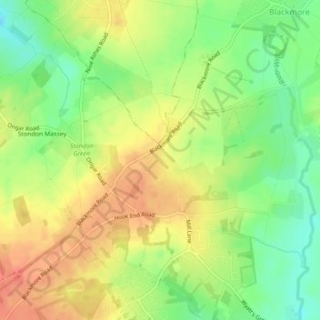
Name: Hook End topographic map, elevation, terrain.

Location: Hook End, Blackmore, Brentwood, Essex, England, United Kingdom (51.67713 0.29951 51.68192 0.30506)

Average elevation: 82 m

Minimum elevation: 56 m

Maximum elevation: 104 m

Gear up for your next adventure:

🍽️Titanium Camping Spork - Ultralight and indestructible eating utensil
🔪Outdoor Multitool - Versatile tool for repairs and food prep in the wild
🧥Thermal Fleece Jacket - Versatile insulation for changing mountain temperatures
🔭Compact Monocular - One-handed bird watching and trail spotting
Camping Essentials - All-in-one gear for a comfortable camping trip

As an Amazon Associate, this site earns from qualifying purchases at no extra cost to you.