
Danebury Hill topographic map
Interactive map
Click on the map to display elevation.
About this map
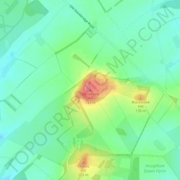
Name: Danebury Hill topographic map, elevation, terrain.
Average elevation: 89 m
Minimum elevation: 63 m
Maximum elevation: 146 m
Other topographic maps
Click on a map to view its topography, its elevation and its terrain.
Withering Corner
United Kingdom > England > Hampshire > Test Valley > Ashley
Withering Corner, Ashley, Test Valley, Hampshire, England, SO20 6RL, United Kingdom
Average elevation: 120 m
Andover
United Kingdom > England > Hampshire > Test Valley
Andover, Test Valley, Hampshire, England, United Kingdom
Average elevation: 90 m
Michelmersh
United Kingdom > England > Hampshire > Test Valley
Michelmersh, Test Valley, Hampshire, England, SO51 0NT, United Kingdom
Average elevation: 49 m
Sandy Down
United Kingdom > England > Hampshire > Test Valley
Sandy Down, Little Somborne, Test Valley, Hampshire, England, SO20 6BY, United Kingdom
Average elevation: 94 m
Romsey
United Kingdom > England > Hampshire > Test Valley
Romsey, Test Valley, Hampshire, England, United Kingdom
Average elevation: 34 m
Penton Mewsey
United Kingdom > England > Hampshire > Test Valley
Penton Mewsey, Test Valley, Hampshire, England, United Kingdom
Average elevation: 91 m
Gosport
United Kingdom > England > Hampshire > Test Valley > Ampfield
Gosport, Ampfield, Crampmoor, Test Valley, Hampshire, England, SO51 9BN, United Kingdom
Average elevation: 46 m
Bullington
United Kingdom > England > Hampshire > Test Valley
Bullington, Test Valley, Hampshire, England, United Kingdom
Average elevation: 73 m
Bossington
United Kingdom > England > Hampshire > Test Valley
Bossington, Test Valley, Hampshire, England, United Kingdom
Average elevation: 46 m
Longparish
United Kingdom > England > Hampshire > Test Valley
Longparish, Middleton, Test Valley, Hampshire, England, United Kingdom
Average elevation: 80 m
Enham Alamein
United Kingdom > England > Hampshire > Test Valley
Enham Alamein, Test Valley, Hampshire, England, United Kingdom
Average elevation: 97 m
Upper Enham
United Kingdom > England > Hampshire > Test Valley
Upper Enham, Test Valley, Hampshire, England, SP11 6HZ, United Kingdom
Average elevation: 120 m
Mottisfont
United Kingdom > England > Hampshire > Test Valley
Mottisfont, Test Valley, Hampshire, England, United Kingdom
Average elevation: 51 m
Hatherden
United Kingdom > England > Hampshire > Test Valley
Hatherden, Test Valley, Hampshire, England, SP11 0DF, United Kingdom
Average elevation: 125 m
Anna Valley
United Kingdom > England > Hampshire > Test Valley
Anna Valley, Test Valley, Hampshire, England, SP11 7NF, United Kingdom
Average elevation: 73 m
Winton Hill
United Kingdom > England > Hampshire > Test Valley > Stockbridge
Winton Hill, Stockbridge, Test Valley, Hampshire, England, SO20 6HL, United Kingdom
Average elevation: 73 m
North Baddesley
United Kingdom > England > Hampshire > Test Valley > North Baddesley
North Baddesley, Test Valley, Hampshire, England, United Kingdom
Average elevation: 42 m
Ashley
United Kingdom > England > Hampshire > Test Valley
Ashley, Test Valley, Hampshire, England, United Kingdom
Average elevation: 92 m
Braishfield
United Kingdom > England > Hampshire > Test Valley
Braishfield, Test Valley, Hampshire, England, United Kingdom
Average elevation: 70 m
Longstock
United Kingdom > England > Hampshire > Test Valley
Longstock, Test Valley, Hampshire, England, United Kingdom
Average elevation: 73 m
Bitterne Grove
United Kingdom > England > Hampshire > Test Valley > Mottisfont > Dunbridge
Bitterne Grove, Dunbridge, Mottisfont, Test Valley, Hampshire, England, SO51 0LF, United Kingdom
Average elevation: 39 m
Upper Clatford
United Kingdom > England > Hampshire > Test Valley
Upper Clatford, Test Valley, Hampshire, England, United Kingdom
Average elevation: 75 m
Weyhill
United Kingdom > England > Hampshire > Test Valley
Penton Grafton, Weyhill, Test Valley, Hampshire, England, United Kingdom
Average elevation: 94 m
Little Ann
United Kingdom > England > Hampshire > Test Valley > Anna Valley
Little Ann, Abbotts Ann, Anna Valley, Test Valley, Hampshire, England, SP11 7NL, United Kingdom
Average elevation: 77 m
Grateley
United Kingdom > England > Hampshire > Test Valley
Grateley, Test Valley, Hampshire, England, United Kingdom
Average elevation: 106 m
Monxton
United Kingdom > England > Hampshire > Test Valley
Monxton, Test Valley, Hampshire, England, United Kingdom
Average elevation: 87 m
Picket Piece
United Kingdom > England > Hampshire > Test Valley
Picket Piece, Test Valley, Hampshire, England, SP11 6WG, United Kingdom
Average elevation: 97 m
Vernham Street
United Kingdom > England > Hampshire > Test Valley
Vernham Street, Test Valley, Hampshire, England, SP11 0EJ, United Kingdom
Average elevation: 178 m
Thruxton Down
United Kingdom > England > Hampshire > Test Valley
Thruxton Down, Thruxton, Test Valley, Hampshire, England, SP11 8PR, United Kingdom
Average elevation: 113 m
Rockmoor Pond
United Kingdom > England > Hampshire > Test Valley > Littledown
Rockmoor Pond, Vernhams Dean, Littledown, Test Valley, Hampshire, England, United Kingdom
Average elevation: 208 m
Vernhams Dean
United Kingdom > England > Hampshire > Test Valley
Vernhams Dean, Test Valley, Hampshire, England, United Kingdom
Average elevation: 183 m
Clanville
United Kingdom > England > Hampshire > Test Valley > Appleshaw
Clanville, Penton Grafton, Appleshaw, Test Valley, Hampshire, England, SP11 9HZ, United Kingdom
Average elevation: 107 m
Ampfield
United Kingdom > England > Hampshire > Test Valley
Ampfield, Test Valley, Hampshire, England, United Kingdom
Average elevation: 51 m
Palestine
United Kingdom > England > Hampshire > Test Valley > Palestine
Palestine, Over Wallop, Test Valley, Hampshire, England, SP11 7EW, United Kingdom
Average elevation: 109 m
Charlton Down
United Kingdom > England > Hampshire > Test Valley > Wildhern > Charlton Down
Charlton Down, Tangley, Wildhern, Test Valley, Hampshire, South East England, England, SP11 0JA, United Kingdom
Average elevation: 111 m
Stockbridge
United Kingdom > England > Hampshire > Test Valley
Stockbridge, Test Valley, Hampshire, England, United Kingdom
Average elevation: 75 m
Tangley
United Kingdom > England > Hampshire > Test Valley
Tangley, Test Valley, Hampshire, South East England, England, United Kingdom
Average elevation: 145 m
Leckford
United Kingdom > England > Hampshire > Test Valley > Leckford
Leckford, Test Valley, Hampshire, South East England, England, United Kingdom
Average elevation: 76 m
Andover
United Kingdom > England > Hampshire > Test Valley > Anna Valley
Andover, Anna Valley, Test Valley, Hampshire, England, United Kingdom
Average elevation: 88 m
Barrow Hill
United Kingdom > England > Hampshire > Test Valley
Barrow Hill, Test Valley, Hampshire, South East England, England, SP11 7RG, United Kingdom
Average elevation: 66 m
Test
United Kingdom > England > Hampshire > Test Valley > Chilbolton
Test, Wherwell, Chilbolton, Test Valley, Hampshire, South East England, England, SO20 6AZ, United Kingdom
Average elevation: 60 m
The Bog
United Kingdom > England > Hampshire > Test Valley > Braishfield > Crookhill
The Bog, Crookhill, Braishfield, Crampmoor, Test Valley, Hampshire, England, United Kingdom
Average elevation: 39 m
Faberstown
United Kingdom > England > Hampshire > Test Valley > Faberstown
Faberstown, Test Valley, Hampshire, South East England, England, SP11 9PB, United Kingdom
Average elevation: 124 m
Middle Wallop
United Kingdom > England > Hampshire > Test Valley > Over Wallop
Middle Wallop, Over Wallop, Test Valley, Hampshire, England, SO20 8EQ, United Kingdom
Average elevation: 80 m
Over Wallop
United Kingdom > England > Hampshire > Test Valley
Over Wallop, Test Valley, Hampshire, England, United Kingdom
Average elevation: 101 m
Quarley
United Kingdom > England > Hampshire > Test Valley
Quarley, Test Valley, Hampshire, South East England, England, United Kingdom
Average elevation: 112 m
Lee
United Kingdom > England > Hampshire > Test Valley > Romsey
Lee, Romsey, Test Valley, Hampshire, England, SO51 9LG, United Kingdom
Average elevation: 23 m
Chilworth
United Kingdom > England > Hampshire > Test Valley
Chilworth, Test Valley, Hampshire, England, United Kingdom
Average elevation: 49 m
Broughton
United Kingdom > England > Hampshire > Test Valley
Broughton, Test Valley, Hampshire, England, United Kingdom
Average elevation: 79 m
Shipton Bellinger
United Kingdom > England > Hampshire > Test Valley
Shipton Bellinger, Test Valley, Hampshire, England, United Kingdom
Average elevation: 126 m