
Make a donation
Gear up for your next adventure:
As an Amazon Associate, this site earns from qualifying purchases at no extra cost to you.
Wietze topographic map
Click on the map to display elevation.
Make a donation
Gear up for your next adventure:
As an Amazon Associate, this site earns from qualifying purchases at no extra cost to you.
About this map
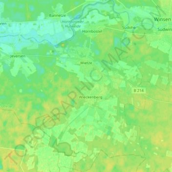
Name: Wietze topographic map, elevation, terrain.
Location: Wietze, Landkreis Celle, Niedersachsen, Deutschland (52.59549 9.73444 52.68975 9.88782)
Average elevation: 35 m
Minimum elevation: 26 m
Maximum elevation: 44 m
Make a donation
Gear up for your next adventure:
As an Amazon Associate, this site earns from qualifying purchases at no extra cost to you.
Other topographic maps
Click on a map to view its topography, its elevation and its terrain.
Make a donation
Gear up for your next adventure:
As an Amazon Associate, this site earns from qualifying purchases at no extra cost to you.
Dalle
Deutschland > Niedersachsen > Landkreis Celle > Eschede
Zu den sieben Ortschaften gehören die Ortsteile und Siedlungen: Aschauteiche | Aschenberg | Burghorn | Habighorster Höhe | Heeseloh | Kragen | Marinesiedlung | Ohe | Queloh | Rebberlah | Schelploh | Starkshorn | Weyhausen
Average elevation: 88 m
Make a donation
Gear up for your next adventure:
As an Amazon Associate, this site earns from qualifying purchases at no extra cost to you.
Oppershausen
Deutschland > Niedersachsen > Landkreis Celle
Bad Langensalza | Bad Tennstedt | Ballhausen | Blankenburg | Bruchstedt | Großvargula | Haussömmern | Herbsleben | Hornsömmern | Kammerforst | Kirchheilingen | Körner | Kutzleben | Marolterode | Mittelsömmern | Mühlhausen/Thüringen | Nottertal-Heilinger Höhen | Oppershausen | Rodeberg | Schönstedt |…
Average elevation: 44 m
Make a donation
Gear up for your next adventure:
As an Amazon Associate, this site earns from qualifying purchases at no extra cost to you.
Henneckenmoor bei Scheuen
Deutschland > Niedersachsen > Landkreis Celle > Celle
Average elevation: 64 m
Lutterloh
Deutschland > Niedersachsen > Landkreis Celle > Südheide > Lutterloh
Average elevation: 94 m
Müden (Örtze)
Deutschland > Niedersachsen > Landkreis Celle
1867 gab es in Müden 28 Bauernhöfe, und ihre Zahl erreichte 1936 mit 98 Betrieben den Höhepunkt. Neben der Landwirtschaft wurde auf der Örtze bis 1912 auch Holzflößerei betrieben. Das in den nahe liegenden Wäldern geschlagene Holz wurde an der Bindestelle zu Flößen zusammengestellt und über die Aller…
Average elevation: 65 m
Make a donation
Gear up for your next adventure:
As an Amazon Associate, this site earns from qualifying purchases at no extra cost to you.
Make a donation
Gear up for your next adventure:
As an Amazon Associate, this site earns from qualifying purchases at no extra cost to you.
Make a donation
Gear up for your next adventure:
As an Amazon Associate, this site earns from qualifying purchases at no extra cost to you.
Make a donation
Gear up for your next adventure:
As an Amazon Associate, this site earns from qualifying purchases at no extra cost to you.
Kanupfad Flotwedel Aller
Deutschland > Niedersachsen > Landkreis Celle > Offensen
Average elevation: 44 m
Make a donation
Gear up for your next adventure:
As an Amazon Associate, this site earns from qualifying purchases at no extra cost to you.
Make a donation
Gear up for your next adventure:
As an Amazon Associate, this site earns from qualifying purchases at no extra cost to you.
Make a donation
Gear up for your next adventure:
As an Amazon Associate, this site earns from qualifying purchases at no extra cost to you.
Make a donation
Gear up for your next adventure:
As an Amazon Associate, this site earns from qualifying purchases at no extra cost to you.
Hof Severloh
Deutschland > Niedersachsen > Landkreis Celle > Südheide > Hermannsburg
Average elevation: 62 m
Hartmannshausen
Deutschland > Niedersachsen > Landkreis Celle > Winsen (Aller) > Meißendorf > Hartmannshausen
Average elevation: 49 m