
Make a donation
Gear up for your next adventure:
As an Amazon Associate, this site earns from qualifying purchases at no extra cost to you.
Baven topographic map
Click on the map to display elevation.
Make a donation
Gear up for your next adventure:
As an Amazon Associate, this site earns from qualifying purchases at no extra cost to you.
About this map
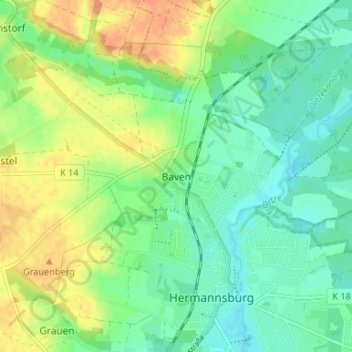
Name: Baven topographic map, elevation, terrain.
Average elevation: 65 m
Minimum elevation: 50 m
Maximum elevation: 88 m
Make a donation
Gear up for your next adventure:
As an Amazon Associate, this site earns from qualifying purchases at no extra cost to you.
Other topographic maps
Click on a map to view its topography, its elevation and its terrain.
Hermannsburg
Deutschland > Niedersachsen > Landkreis Celle > Südheide
Am 24. April 1903 wurde der Grundstein für die heutige Christianschule gelegt. Aus dem Vermögen des im Alter von 16 Jahren verstorbenen Prinzen Christian von Hannover (1885–1901), einem Sohn des Ernst August, Kronprinz von Hannover und Herzog von Cumberland (1845–1923), vermachte Prinz Christians Tante…
Average elevation: 71 m
Make a donation
Gear up for your next adventure:
As an Amazon Associate, this site earns from qualifying purchases at no extra cost to you.