Geolocate

Stansty topographic map

Click on the map to display elevation.

About this map

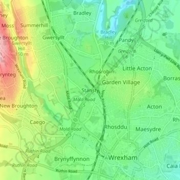
Name: Stansty topographic map, elevation, terrain.

Location: Stansty, Gwersyllt, Wrexham, Wales, LL11 2BF, United Kingdom (53.04151 -3.02585 53.08151 -2.98585)

Average elevation: 96 m

Minimum elevation: 44 m

Maximum elevation: 201 m

Other topographic maps

Click on a map to view its topography, its elevation and its terrain.

Gwersyllt

United Kingdom > Wales > Wrexham

Average elevation: 112 m

Penycae

United Kingdom > Wales > Wrexham

Average elevation: 350 m

Rhosddu

United Kingdom > Wales > Wrexham

Average elevation: 88 m

Bangor-on-Dee

United Kingdom > Wales > Wrexham

Average elevation: 30 m

Cefn

United Kingdom > Wales > Wrexham > Acrefair

Average elevation: 142 m

Gear up for your next adventure:

🧰Emergency Multi-Tool - Compact multi-tool for outdoor survival
👖Convertible Hiking Pants - Zip-off legs to adapt to changing weather conditions
🥾Light Hiking Boots - Lightweight and comfortable boots for day hikes
🧴First Aid Kit - Essential first aid supplies for outdoor emergencies
🔥Camping Stove - Portable stoves to cook outdoors with ease

As an Amazon Associate, this site earns from qualifying purchases at no extra cost to you.