Geolocate

Grad Ivanec topographic map

Click on the map to display elevation.

About this map

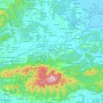
Name: Grad Ivanec topographic map, elevation, terrain.

Location: Grad Ivanec, Varaždin County, Croatia (46.17885 16.04850 46.26467 16.27675)

Average elevation: 320 m

Minimum elevation: 177 m

Maximum elevation: 1,049 m

Other topographic maps

Click on a map to view its topography, its elevation and its terrain.

Novi Marof

Croatia > Varaždin County

Average elevation: 253 m

Ivanščica

Croatia > Varaždin County > Grad Ivanec

Average elevation: 770 m

Gornje Vratno

Croatia > Varaždin County

Average elevation: 216 m

Bela

Croatia > Varaždin County

Average elevation: 293 m

Bela

Croatia > Varaždin County

Average elevation: 293 m

Trakošćan

Croatia > Varaždin County

Average elevation: 293 m

Gear up for your next adventure:

👖Convertible Hiking Pants - Zip-off legs to adapt to changing weather conditions
🛏️Camping Sleeping Mat - Comfortable mats for sleeping outdoors
🧼Biodegradable Camp Soap - Environmentally friendly cleaning for gear and body
👟Trail Running Shoes - Agile footwear for fast-paced topographic exploration
🎒Hiking Daypack - Lightweight and durable backpacks for day trips and excursions

As an Amazon Associate, this site earns from qualifying purchases at no extra cost to you.