Geolocate

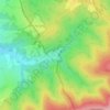
Adamov topographic map

Click on the map to display elevation.

About this map

Name: Adamov topographic map, elevation, terrain.

Location: Adamov, okres Blansko, South Moravian Region, 679 04, Czechia (49.28439 16.63984 49.31392 16.69172)

Average elevation: 381 m

Minimum elevation: 236 m

Maximum elevation: 525 m

Other topographic maps

Click on a map to view its topography, its elevation and its terrain.
Hnízdo

Czechia > South Moravian Region

Average elevation: 232 m

Vápenky

Czechia > South Moravian Region > Nová Lhota

Average elevation: 578 m

Gear up for your next adventure:

🛌Down Sleeping Bag - Superior warmth-to-weight ratio for cold nights
🧭GPS Tracker - Track your location in remote areas safely
🧢Hiking Sun Hat - Wide-brimmed protection for exposed mountain ridges
🧴Sunscreen SPF - Broad-spectrum sunscreen for outdoor activities
🕶️Polarized Sunglasses - Reduces glare from snow and water at high elevations

As an Amazon Associate, this site earns from qualifying purchases at no extra cost to you.