
Roussimel topographic map
Click on the map to display elevation.
About this map
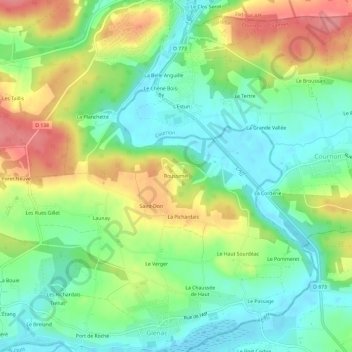
Name: Roussimel topographic map, elevation, terrain.
Average elevation: 35 m
Minimum elevation: -1 m
Maximum elevation: 90 m
Other topographic maps
Click on a map to view its topography, its elevation and its terrain.
Glénac
France > Bretagne > Morbihan > La Gacilly
La superficie de l’ancienne commune est de 1 370 hectares (13,7 km2) ; son altitude varie entre 2 et 87 m.
Average elevation: 31 m
La Gacilly
France > Bretagne > Morbihan > La Gacilly
La superficie de la commune est de 1 648 hectares ; son altitude varie de 4 à 98 mètres.
Average elevation: 41 m
La Chapelle-Gaceline
France > Bretagne > Morbihan > La Gacilly
La superficie de la commune est de 779 hectares ; son altitude varie de 5 à 52 mètres.
Average elevation: 25 m
La Gacilly
France > Bretagne > Morbihan > La Gacilly
La superficie de la commune est de 1 648 hectares ; son altitude varie de 4 à 98 mètres.
Average elevation: 41 m