Geolocate

Glénac topographic map

Click on the map to display elevation.

Glénac

La superficie de l’ancienne commune est de 1 370 hectares (13,7 km2) ; son altitude varie entre 2 et 87 m.

Wikipedia (CC-BY-SA 3.0)

About this map

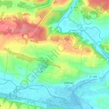
Name: Glénac topographic map, elevation, terrain.

Location: Glénac, La Gacilly, Vannes, Morbihan, Bretagne, France métropolitaine, 56200, France (47.71743 -2.17544 47.75852 -2.10680)

Average elevation: 31 m

Minimum elevation: -2 m

Maximum elevation: 92 m

Other topographic maps

Click on a map to view its topography, its elevation and its terrain.

Le Chêne

France > Bretagne > Morbihan > La Gacilly

Average elevation: 24 m

Le Pâtis

France > Bretagne > Morbihan > La Gacilly

Average elevation: 38 m

La Glouzie

France > Bretagne > Morbihan > La Gacilly

Average elevation: 38 m

La Moraie

France > Bretagne > Morbihan > La Gacilly

Average elevation: 27 m

Roussimel

France > Bretagne > Morbihan > La Gacilly

Average elevation: 35 m

La Vigne

France > Bretagne > Morbihan > La Gacilly

Average elevation: 33 m

Gazeau

France > Bretagne > Morbihan > La Gacilly

Average elevation: 36 m

Le Pommeret

France > Bretagne > Morbihan > La Gacilly

Average elevation: 26 m

Gear up for your next adventure:

❄️Traction Ice Cleats - Slip-on spikes for icy trails and winter hiking
🥾All-Terrain Hiking Boots - Versatile boots for varied hiking conditions
🔋Emergency Crank Radio - Weather alerts and power without needing batteries
🪜Heavy Duty Carabiners - Multi-use clips for securing gear to your backpack
🧰Survival Kit - Essential gear for emergencies in the wilderness

As an Amazon Associate, this site earns from qualifying purchases at no extra cost to you.