Geolocate

Kedu topographic map

Click on the map to display elevation.

About this map

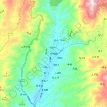
Name: Kedu topographic map, elevation, terrain.

Location: Kedu, Kunming, Yunnan, China (25.51122 102.81557 25.59122 102.89557)

Average elevation: 2,104 m

Minimum elevation: 1,790 m

Maximum elevation: 2,699 m

Other topographic maps

Click on a map to view its topography, its elevation and its terrain.

Shilin Yi Autonomous County

China > Yunnan > Kunming

Average elevation: 1,882 m

Panlong District

China > Yunnan > Kunming

Average elevation: 2,137 m

Dabanqiao Subdistrict

China > Yunnan > Kunming

Average elevation: 2,093 m

Shilin Yi Autonomous County

China > Yunnan > Kunming

Average elevation: 1,882 m

Tuodong Subdistrict

China > Yunnan > Kunming

Average elevation: 1,901 m

Songming County

China > Yunnan > Kunming

Average elevation: 2,067 m

Gear up for your next adventure:

🧥Fleece Jacket - Warm and lightweight jacket for layering
🧥Waterproof Pants - Keep dry during rainy hiking conditions
👟Sport Hiking Sandals - Breathable footwear for water crossings and camp rest
🛶Waterproof Dry Bags - Keep electronics and clothes dry during river crossings
🕶️Polarized Sunglasses - Reduces glare from snow and water at high elevations

As an Amazon Associate, this site earns from qualifying purchases at no extra cost to you.