Geolocate

Girardot topographic map

Click on the map to display elevation.

About this map

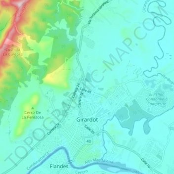
Name: Girardot topographic map, elevation, terrain.

Location: Girardot, Cundinamarca, Colombia (4.28596 -74.83541 4.35520 -74.76035)

Average elevation: 323 m

Minimum elevation: 248 m

Maximum elevation: 710 m

Other topographic maps

Click on a map to view its topography, its elevation and its terrain.

Girardot

Colombia > Cundinamarca > Girardot

Average elevation: 397 m

Gear up for your next adventure:

🥾All-Terrain Hiking Boots - Versatile boots for varied hiking conditions
🔋Emergency Crank Radio - Weather alerts and power without needing batteries
🧴Waterproofing Spray - Restore the DWR coating on jackets and tents
🧴First Aid Kit - Essential first aid supplies for outdoor emergencies
🧢Outdoor Cap - Protective cap for sun and rain during hikes

As an Amazon Associate, this site earns from qualifying purchases at no extra cost to you.