Geolocate

Girardot topographic map

Click on the map to display elevation.

About this map

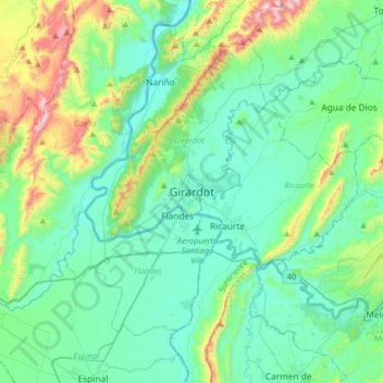
Name: Girardot topographic map, elevation, terrain.

Location: Girardot, Cundinamarca, 252431, Colombia (4.14664 -74.96157 4.46664 -74.64157)

Average elevation: 397 m

Minimum elevation: 228 m

Maximum elevation: 1,056 m

Other topographic maps

Click on a map to view its topography, its elevation and its terrain.

Girardot

Colombia > Cundinamarca > Girardot

Average elevation: 323 m

Girardot

Colombia > Cundinamarca > Girardot

Average elevation: 390 m

Gear up for your next adventure:

🥾Mountain Trail Shoes - High-traction shoes for mountain trails
👟Trail Running Shoes - Agile footwear for fast-paced topographic exploration
🔪Outdoor Multitool - Versatile tool for repairs and food prep in the wild
🥾Hiking Leggings - Comfortable leggings for outdoor activities
🔦UV Flashlight - Detect minerals or specific insects in the dark

As an Amazon Associate, this site earns from qualifying purchases at no extra cost to you.