
Stenico topographic map
Click on the map to display elevation.
About this map
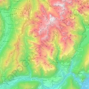
Name: Stenico topographic map, elevation, terrain.
Average elevation: 1,444 m
Minimum elevation: 242 m
Maximum elevation: 3,137 m
Other topographic maps
Click on a map to view its topography, its elevation and its terrain.
Sardagna
Italy > Trentino – Alto Adige/Südtirol > Provincia di Trento > Trento
Average elevation: 579 m
Sopramonte
Italy > Trentino – Alto Adige/Südtirol > Provincia di Trento > Trento
Average elevation: 718 m
Tuenno
Italy > Trentino – Alto Adige/Südtirol > Provincia di Trento > Ville d'Anaunia
Average elevation: 744 m
Vignole
Italy > Trentino – Alto Adige/Südtirol > Provincia di Trento > Arco > Bolognano
Average elevation: 388 m
Colder
Italy > Trentino – Alto Adige/Südtirol > Provincia di Trento > Tiarno di Sopra
Average elevation: 967 m
Val Lasties
Italy > Trentino – Alto Adige/Südtirol > Provincia di Trento > Canazei
Average elevation: 2,544 m