Geolocate

Svelvik topographic map

Click on the map to display elevation.

About this map

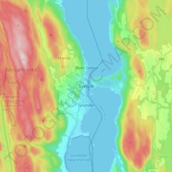
Name: Svelvik topographic map, elevation, terrain.

Location: Svelvik, Drammen, Buskerud, 3060, Norway (59.57352 10.36911 59.65352 10.44911)

Average elevation: 138 m

Minimum elevation: -2 m

Maximum elevation: 389 m

Other topographic maps

Click on a map to view its topography, its elevation and its terrain.

Kongsberg

Norway > Buskerud

Average elevation: 388 m

Hemsedal

Norway > Buskerud

Average elevation: 1,217 m

Norefjell

Norway > Buskerud

Average elevation: 758 m

Hol

Norway > Buskerud

Average elevation: 1,204 m

Flå

Norway > Buskerud

Average elevation: 719 m

Ringerike

Norway > Buskerud

Average elevation: 443 m

Flesberg

Norway > Buskerud

Average elevation: 520 m

Hemsedal

Norway > Buskerud

Average elevation: 1,217 m

Hemsedal

Norway > Buskerud

Average elevation: 1,217 m

Flesberg

Norway > Buskerud

Average elevation: 520 m

Ål

Norway > Buskerud

The Bergen Line, the rail line between Oslo and Bergen runs through Ål. Ål Station has an elevation of 436 meters (1,430 ft) and is the halfway station on the Bergen Line.

Average elevation: 1,023 m

Hemsedal

Norway > Buskerud

Average elevation: 1,217 m

Hole

Norway > Buskerud

Average elevation: 266 m

Drammen

Norway > Buskerud

Average elevation: 209 m

Nesbyen

Norway > Buskerud

Average elevation: 842 m

Gear up for your next adventure:

🛌Down Sleeping Bag - Superior warmth-to-weight ratio for cold nights
👖Convertible Hiking Pants - Zip-off legs to adapt to changing weather conditions
🦟Insect Repellent - Keep mosquitoes and black flies away in wooded areas
👟Sport Hiking Sandals - Breathable footwear for water crossings and camp rest
🔦LED Flashlight - Powerful and long-lasting flashlight for camping and emergencies

As an Amazon Associate, this site earns from qualifying purchases at no extra cost to you.