Geolocate

Hol topographic map

Click on the map to display elevation.

About this map

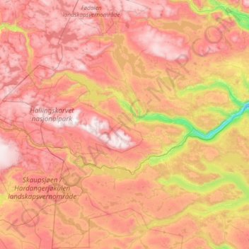
Name: Hol topographic map, elevation, terrain.

Location: Hol, Viken, Norway (60.34103 7.43884 60.86657 8.62250)

Average elevation: 1,204 m

Minimum elevation: 427 m

Maximum elevation: 1,923 m

Other topographic maps

Click on a map to view its topography, its elevation and its terrain.

Kjeller

Norway > Viken

Average elevation: 121 m

Lillestrøm

Norway > Viken

Average elevation: 149 m

Gear up for your next adventure:

🛏️Sleeping Bag - Warm and compact sleeping bags for outdoor camping
🧭GPS Outdoor Watch - Smart watch for navigation and fitness tracking in nature
🧥Thermal Layer - Insulating layer for cold outdoor conditions
🥾Hiking Gaiters - Protect legs and shoes from mud, snow, and debris
🧥Waterproof Jacket - Lightweight rain jackets for hiking and outdoor activities

As an Amazon Associate, this site earns from qualifying purchases at no extra cost to you.