
Make a donation
Gear up for your next adventure:
As an Amazon Associate, this site earns from qualifying purchases at no extra cost to you.
Vieu topographic map
Click on the map to display elevation.
Make a donation
Gear up for your next adventure:
As an Amazon Associate, this site earns from qualifying purchases at no extra cost to you.
About this map
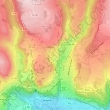
Name: Vieu topographic map, elevation, terrain.
Average elevation: 428 m
Minimum elevation: 246 m
Maximum elevation: 546 m
Make a donation
Gear up for your next adventure:
As an Amazon Associate, this site earns from qualifying purchases at no extra cost to you.
Other topographic maps
Click on a map to view its topography, its elevation and its terrain.
Make a donation
Gear up for your next adventure:
As an Amazon Associate, this site earns from qualifying purchases at no extra cost to you.
Blanod
France > Auvergne-Rhône-Alpes > Ain > Valromey-sur-Séran > Sutrieu > Blanod
Average elevation: 708 m
Le Puys des Barres
France > Auvergne-Rhône-Alpes > Ain > Valromey-sur-Séran > Sutrieu > Le Puys des Barres
Average elevation: 813 m