
Make a donation
Gear up for your next adventure:
As an Amazon Associate, this site earns from qualifying purchases at no extra cost to you.
Massignieu topographic map
Click on the map to display elevation.
Make a donation
Gear up for your next adventure:
As an Amazon Associate, this site earns from qualifying purchases at no extra cost to you.
About this map
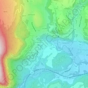
Name: Massignieu topographic map, elevation, terrain.
Average elevation: 425 m
Minimum elevation: 238 m
Maximum elevation: 902 m
Make a donation
Gear up for your next adventure:
As an Amazon Associate, this site earns from qualifying purchases at no extra cost to you.
Other topographic maps
Click on a map to view its topography, its elevation and its terrain.
Sutrieu
France > Auvergne-Rhône-Alpes > Ain > Valromey-sur-Séran
La superficie de la commune est de 1 905 hectares ; son altitude varie entre 459 et 1 200 mètres.
Average elevation: 697 m
Make a donation
Gear up for your next adventure:
As an Amazon Associate, this site earns from qualifying purchases at no extra cost to you.