Geolocate

Castellanza topographic map

Click on the map to display elevation.

About this map

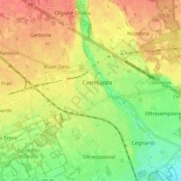
Name: Castellanza topographic map, elevation, terrain.

Location: Castellanza, Varese, Lombardy, 21053, Italy (45.59197 8.86406 45.62643 8.93637)

Average elevation: 221 m

Minimum elevation: 190 m

Maximum elevation: 247 m

Other topographic maps

Click on a map to view its topography, its elevation and its terrain.

Barza

Italy > Lombardy > Varese

Average elevation: 226 m

San Clemente

Italy > Lombardy > Varese > Caravate

Average elevation: 275 m

Gear up for your next adventure:

🧦Hiking Socks - Moisture-wicking and comfortable socks for long hikes
🧥Thermal Fleece Jacket - Versatile insulation for changing mountain temperatures
🪑Insulated Seat Pad - Protect your seat from cold rocks and wet logs
🧦Hiking Liner Socks - Thin base layer to prevent friction and blisters
🐕Hiking Dog Pack - Let your canine companion carry their own water and food

As an Amazon Associate, this site earns from qualifying purchases at no extra cost to you.