
Make a donation
Gear up for your next adventure:
As an Amazon Associate, this site earns from qualifying purchases at no extra cost to you.
Windberg topographic map
Click on the map to display elevation.
Make a donation
Gear up for your next adventure:
As an Amazon Associate, this site earns from qualifying purchases at no extra cost to you.
About this map
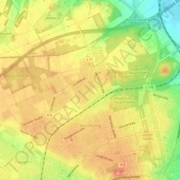
Name: Windberg topographic map, elevation, terrain.
Average elevation: 72 m
Minimum elevation: 39 m
Maximum elevation: 89 m
Make a donation
Gear up for your next adventure:
As an Amazon Associate, this site earns from qualifying purchases at no extra cost to you.
Other topographic maps
Click on a map to view its topography, its elevation and its terrain.
Mönchengladbach
Deutschland > Nordrhein-Westfalen > Mönchengladbach
Der höchste Punkt ist die mit 133 m ü. NN nach dem Zweiten Weltkrieg aus Trümmern aufgeschüttete Rheydter Höhe. Der niedrigste Punkt sind die Nierswiesen im Stadtteil Donk mit 35 m ü. NN. Die Länge der Stadtgrenze beträgt insgesamt 86 Kilometer. Die größte Nord-Süd-Ausdehnung beträgt 17; die…
Average elevation: 59 m
Make a donation
Gear up for your next adventure:
As an Amazon Associate, this site earns from qualifying purchases at no extra cost to you.
Make a donation
Gear up for your next adventure:
As an Amazon Associate, this site earns from qualifying purchases at no extra cost to you.
Make a donation
Gear up for your next adventure:
As an Amazon Associate, this site earns from qualifying purchases at no extra cost to you.