
Make a donation
Gear up for your next adventure:
As an Amazon Associate, this site earns from qualifying purchases at no extra cost to you.
South Park topographic map
Click on the map to display elevation.
Make a donation
Gear up for your next adventure:
As an Amazon Associate, this site earns from qualifying purchases at no extra cost to you.
About this map
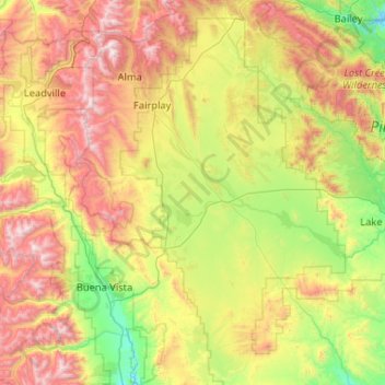
Name: South Park topographic map, elevation, terrain.
Location: South Park, Park County, Colorado, United States (38.63610 -106.11162 39.44303 -105.37357)
Average elevation: 3,013 m
Minimum elevation: 2,290 m
Maximum elevation: 4,370 m
Make a donation
Gear up for your next adventure:
As an Amazon Associate, this site earns from qualifying purchases at no extra cost to you.
Other topographic maps
Click on a map to view its topography, its elevation and its terrain.
Kenosha Pass
United States > Colorado > Park County
Kenosha Pass, elevation 10,000 ft (3,000 m), is a high mountain pass located in the Rocky Mountains of central Colorado in the United States.
Average elevation: 3,047 m
Make a donation
Gear up for your next adventure:
As an Amazon Associate, this site earns from qualifying purchases at no extra cost to you.