
Lee Vining topographic map
Click on the map to display elevation.
Lee Vining
Lee Vining (formerly Leevining, Poverty Flat, and Lakeview) is an unincorporated community and census-designated place (CDP) in Mono County, California, United States. It is located 25 miles (40 km) south-southeast of Bridgeport, at an elevation of 6,781 feet (2,067 m). Lee Vining is located on the southwest shore of Mono Lake. The population was 217 as of the 2020 census.
About this map
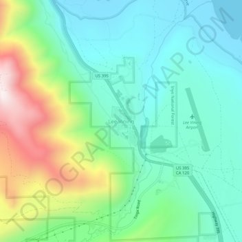
Name: Lee Vining topographic map, elevation, terrain.
Location: Lee Vining, Mono County, California, 93541, United States (37.93743 -119.14182 37.97743 -119.10182)
Average elevation: 2,180 m
Minimum elevation: 1,945 m
Maximum elevation: 2,768 m
Other topographic maps
Click on a map to view its topography, its elevation and its terrain.
Mammoth Lakes
United States > California > Mono County
Mammoth Lakes is a town in Mono County, California, and is the county's only incorporated community. It is located immediately to the east of Mammoth Mountain, at an elevation of 7,880 feet (2,400 m). As of the 2020 United States Census, the population was 7,191, reflecting a 12.7% decrease from the 2010…
Average elevation: 2,682 m
June Lake
United States > California > Mono County > June Lake
Because the community is built on hills and meadows in this subalpine valley surrounded by high mountain peaks, it has been dubbed the "Switzerland of California." The area is notable for its trout fishing. Hiking is a favorite pastime of the area: June Lake offers many trails that lead into the nearby back…
Average elevation: 2,531 m
Bridgeport
United States > California > Mono County > Bridgeport
Bridgeport is in northwestern Mono County and lies at an elevation of 6,463 feet (1,970 m) in the middle of the Bridgeport Valley. The valley is ringed by mountains with the Sierra Nevada to the west, the Sweetwater Mountains to the north, and the Bodie Hills to the east.
Average elevation: 2,074 m
Mammoth Lakes
United States > California > Mono County
Mammoth Lakes is the only incorporated town in Mono County, California, United States. It is located immediately to the east of Mammoth Mountain, at an elevation of 7,880 feet (2,400 m). As of the 2020 United States census, the population was 7,191, reflecting a 12.7% decrease from the 2010 Census.
Average elevation: 2,682 m
Mono Lake
United States > California > Mono County
Lake Russell was the prehistoric predecessor to Mono Lake, during the Pleistocene. Its shoreline reached the modern-day elevation of 7,480 feet (2,280 m), about 1,100 feet (330 m) higher than the present-day lake. As of 1.6 million years ago, Lake Russell discharged to the northeast, into the Walker River…
Average elevation: 2,008 m
Mammoth Lakes
United States > California > Mono County
Mammoth Lakes is a town in Mono County, California, and is the county's only incorporated community. It is located immediately to the east of Mammoth Mountain, at an elevation of 7,880 feet (2,400 m). As of the 2020 United States Census, the population was 7,191, reflecting a 12.7% decrease from the 2010…
Average elevation: 2,682 m
June Lake
United States > California > Mono County > June Lake
June Lake is a census-designated place in Mono County, California. It is located against the southern rim of the Mono Basin, 12.5 miles (20 km) south of Lee Vining, at an elevation of 7654 feet (2333 m).
Average elevation: 2,445 m
Bridgeport
United States > California > Mono County > Bridgeport
Bridgeport is in northwestern Mono County and lies at an elevation of 6,463 feet (1,970 m) in the middle of the Bridgeport Valley. The valley is ringed by mountains with the Sierra Nevada to the west, the Sweetwater Mountains to the north, and the Bodie Hills to the east.
Average elevation: 2,074 m