
Ompton CP topographic map
Click on the map to display elevation.
About this map
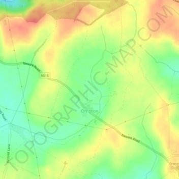
Name: Ompton CP topographic map, elevation, terrain.
Average elevation: 79 m
Minimum elevation: 52 m
Maximum elevation: 102 m
Other topographic maps
Click on a map to view its topography, its elevation and its terrain.
Vicar Water Country Park
United Kingdom > England > Nottinghamshire > Newark and Sherwood > Clipstone
Average elevation: 97 m
Newark on Trent
United Kingdom > England > Nottinghamshire > Newark and Sherwood
Average elevation: 18 m
Sherwood Forest NNR
United Kingdom > England > Nottinghamshire > Newark and Sherwood > Ollerton
Average elevation: 71 m
Danethorpe Hill
United Kingdom > England > Nottinghamshire > Newark and Sherwood
Average elevation: 22 m
Farndon
United Kingdom > England > Nottinghamshire > Newark and Sherwood > Farndon
Average elevation: 14 m
Blidworth Bottoms
United Kingdom > England > Nottinghamshire > Newark and Sherwood > Blidworth CP
Average elevation: 107 m
Goverton
United Kingdom > England > Nottinghamshire > Newark and Sherwood > Bleasby
Average elevation: 34 m
Spalford Warren
United Kingdom > England > Nottinghamshire > Newark and Sherwood > Spalford
Average elevation: 7 m
Kings Clipstone
United Kingdom > England > Nottinghamshire > Newark and Sherwood
Average elevation: 81 m
Sherwood Forest NNR
United Kingdom > England > Nottinghamshire > Newark and Sherwood > Ollerton
Average elevation: 71 m