
Sleaford topographic map
Click on the map to display elevation.
Sleaford
The town centre lies about 49 feet (15 m) above sea level and has formed around the River Slea, which runs west to north-east through it. A band of Jurassic Cornbrash limestone forms the bedrock under Holdingham (where the ground rises to 82 feet (25 m) above sea level in places), parts of central Sleaford, and most of the housing at Quarrington (where elevations exceed over 98 feet (30 m) at Quarrington Hill) and southern Greylees. The bedrock on the eastern parts of the town comprises Jurassic Kellaways sandstone and siltstone. To the west, the Slea follows a shallow valley underlain by Jurassic Blisworth clay and limestone and, at its lowest elevations at Quarrington Fen and Boiling Wells Farm, earlier Jurassic Rutland argillaceous rocks and Upper Lincolnshire limestone. Greylees and the northern fringe of the Quarrington Hill estate sit on the southern edge of this valley, on the Blisworth clays and limestone. Alluvium deposits are found along the Slea's course, and sand and gravel of the Sleaford series are found to the east and south. Most of the soil is free-draining, lime-rich and loamy, though some of the eastern parts are on loamy soils with naturally high groundwater.
About this map
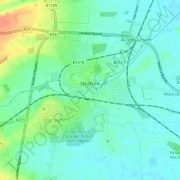
Name: Sleaford topographic map, elevation, terrain.
Average elevation: 18 m
Minimum elevation: 7 m
Maximum elevation: 48 m