Geolocate

Aurich topographic map

Click on the map to display elevation.

About this map

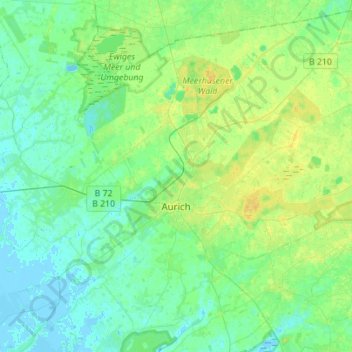
Name: Aurich topographic map, elevation, terrain.

Location: Aurich, Landkreis Aurich, Lower Saxony, Germany (53.40544 7.40164 53.56180 7.67909)

Average elevation: 6 m

Minimum elevation: -3 m

Maximum elevation: 16 m

Other topographic maps

Click on a map to view its topography, its elevation and its terrain.

Arle

Germany > Lower Saxony > Landkreis Aurich > Großheide

Average elevation: 2 m

Arle

Germany > Lower Saxony > Landkreis Aurich > Großheide

Average elevation: 2 m

Greetsiel

Germany > Lower Saxony > Landkreis Aurich

Average elevation: -1 m

Gear up for your next adventure:

🔪Outdoor Multitool - Versatile tool for repairs and food prep in the wild
🧴Outdoor Sunscreen - High SPF protection for high-altitude UV exposure
🛰️Satellite Messenger - Emergency communication for areas with no cell service
🥾Trail Hiking Shoes - Durable shoes designed for rugged trails
🧥Waterproof Hiking Jacket - Protect yourself from rain and wind while hiking

As an Amazon Associate, this site earns from qualifying purchases at no extra cost to you.