
Make a donation
Gear up for your next adventure:
As an Amazon Associate, this site earns from qualifying purchases at no extra cost to you.
La Glace topographic map
Click on the map to display elevation.
Make a donation
Gear up for your next adventure:
As an Amazon Associate, this site earns from qualifying purchases at no extra cost to you.
La Glace
La Glace is a hamlet in northern Alberta, Canada within the County of Grande Prairie No. 1. It is located along Highway 59 between Sexsmith and Valhalla Centre and has an elevation of 735 metres (2,411 ft).
Make a donation
Gear up for your next adventure:
As an Amazon Associate, this site earns from qualifying purchases at no extra cost to you.
About this map
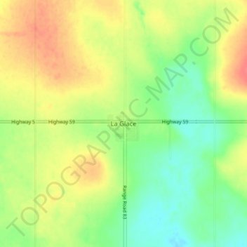
Name: La Glace topographic map, elevation, terrain.
Average elevation: 738 m
Minimum elevation: 713 m
Maximum elevation: 764 m
County of Grande Prairie trails, hiking, mountain biking, running and outdoor activities
Make a donation
Gear up for your next adventure:
As an Amazon Associate, this site earns from qualifying purchases at no extra cost to you.
Other topographic maps
Click on a map to view its topography, its elevation and its terrain.